
Eye in the sky: How space technology helps tackle climate change

As of 2020, climate change is, beyond doubt, a global emergency and the window to restrict its cascading effects is closing very fast1. Conferences like the United Nations Climate Change Conference or COP (which is happening in Glasgow this year2 are part of global efforts to sensitise people. Various industries are now awakening to this global crisis and have started taking measures to counter climate change issues. The space sector is leading such efforts in helping governments derive policies and direct efforts.
The space industry, operating through various space agencies and private corporations, is at the forefront of data collection and research about climate change. The major players in these efforts are space agencies like NASA, ESA, ISRO, CNES and private companies like Airbus, Boeing, Thales Alenia Space and many more. Over the last few years, various space missions have been flown with a focus on gathering and analysing climate change data. Any space mission about climate change involves ‘Earth observation’ and this is done via satellites that carry cutting-edge technological equipment to track specific physical quantities from altitudes as high as 800km.
Since climate change affects the entire ecosystem on Earth, it is important to know the causes of such changes and how to mitigate possible dangers. To understand when, where and why climate changes and how it affects us, there are various parameters to observe over a long period of time. Space missions monitor changes in areas such as forest cover, ice thickness in polar regions, sea-level rise, ocean currents and salinity, atmospheric CO2 and ozone, extreme weather conditions, and more. Here are some of the interesting space missions that have been helping tackle climate change.
Polar ice measurements
One of the major causes of rising sea levels is melting polar ice caps. The polar ice holds water in huge amounts and, when melted, it’s released into the oceans. So by monitoring the rates of ice accumulation and ice loss in Earth’s polar regions, and measuring the density and thickness of ice and weather changes among others, we can estimate how much water may be released into the oceans over time. Last year, scientists studying ice sheets discovered3 that warm ocean water has accelerated thinning of polar ice sheets. Now, nearly a quarter of glacier ice in West Antarctica is unstable.
NASA’s Ice, Cloud, and land Elevation Satellite (ICESat-2) is the latest satellite dedicated to measuring the elevation of ice sheets and sea ice. The satellite has a high-end global positioning system (GPS) on board, along with the ability to track its centre of gravity. This can determine its position in orbit very accurately4. The height measuring instrument on ICESat-2 is called ATLAS and it includes a laser radar. Unlike its predecessors, a single laser beam is split into 6 different beams to cover more ground. With up to 10,000 pulses of photons per second, ATLAS can measure data every 70cm along its path. The splitting of the beam also helps in measuring terrain slope. The reflected photons are then captured by a telescope aligned with it to determine elevation. ICESat-2 aims to help estimate how polar ice sheets can influence sea-level changes by gathering data for ice sheet modelling and to estimate sea ice thickness5 6.
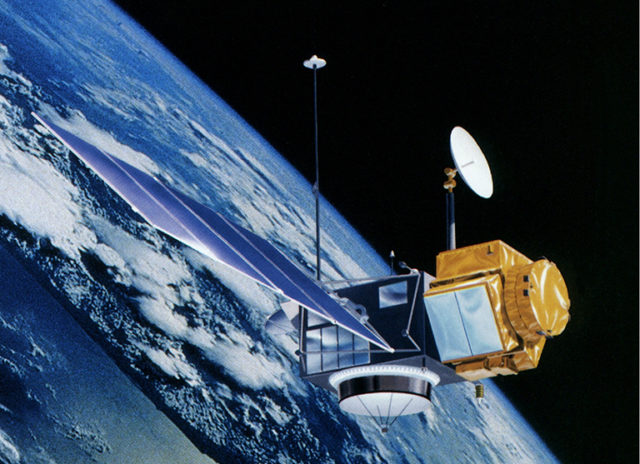
Tracking ocean-level rise
Post-industrialisation and, since the beginning of urbanisation, we’ve been exposed to the threat of rising ocean levels. The threat to countries like the Netherlands (where a quarter of the country is below sea level) and island nations like the Maldives and the Marshall Islands is very real. We’re already hearing about such possibilities turning into reality. Recently, the Indonesian government approved plans to move the capital, Jakarta, 100 miles away to avoid rising sea levels, with research suggesting parts of the city will be fully submerged by 20507
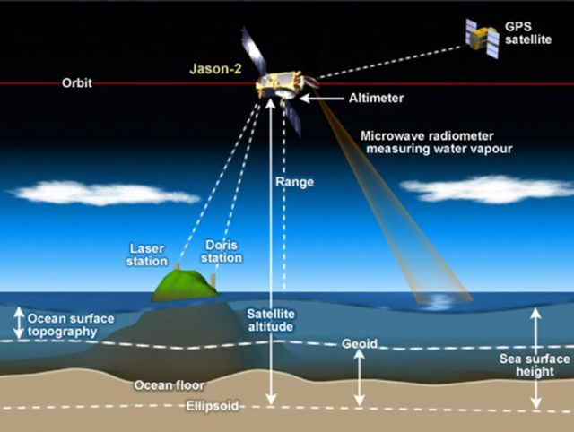
Satellites have been tracking changes in global sea levels since the early 90s. Using a technique called radar altimetry, changes in surface levels over land, sea and ice are recorded by various satellite missions like JASON and Sentinel. These records show that the oceans have been rising at over 3mm per year8 and this has accelerated in recent years. While this growth is not uniform across the globe, it certainly rings danger bells.
So how are such small changes in ocean level measured? Radar altimetry involves the transmission of short radar pulses and detecting their reflection. By recording the time interval between the two, the distance travelled by the pulses can be measured. This distance is then compared with the satellite’s accurate location in space to find the change in the ocean surface height. With stringent calibration, accurate changes in ocean surface level are determined. ESA is launching a satellite, Sentinel 6, later this year that uses this technology.
Detection of wildfires
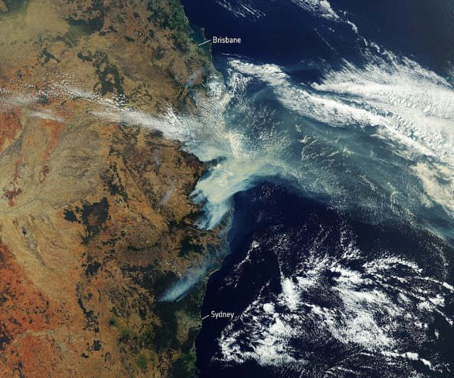
From an environmental perspective, 2019 ended on a sad note, with unprecedented bushfires raging across Australia. This indicated how climate change leading to drier weather can act as a catalyst to wildfires. It’s been fairly obvious that extreme weather, and weather conditions causing wildfires, have been on the rise9. So it’s important to find patterns that lead to such devastating fires. Even before forest fires were this frequent, observation from space was prevalent. A NASA mission, Suomi NPP, has been very useful to detect weather patterns that lead to wildfires. While wildfires are generally considered unpredictable, scientists at the University of Maryland devised a way to highlight ‘weather signatures’ that indicate the possibility of wildfires using this data10. Although accurate prediction of wildfires is still a challenge, the imagery and climate data from NASA satellites like Suomi NPP and Terra, and ESA satellites from the Sentinel series, help direct efforts to contain the wildfires. There are also wider collaborative efforts like the Global Fire Weather Database (GFWED)11, through which various weather factors causing the start and spread of wildfires are analysed.
Ozone watch
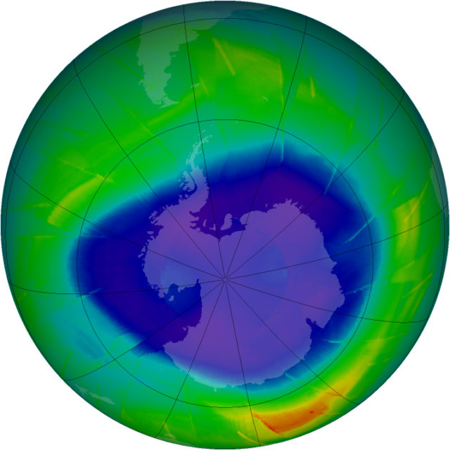
One of the early newsmakers on climate change was the ozone layer depletion in the 90s. The ozone layer, which protects us by absorbing harmful radiation, changes in spread and volume periodically. Hence, it needs to be monitored and analysed. NASA, maintains a live database12 of ozone-related data obtained from various space missions.
One of the oldest missions launched to monitor ozone is NASA’s Upper Atmosphere Research Satellite (UARS)13 It’s still active after 28 years and is part of the Halogen Occultation Experiment (HALOE) programme. It measures the composition of our upper atmosphere (the stratosphere, where natural ozone exists) using a phenomenon called solar occultation. When UARS orbits the Earth, in 24 hours it experiences 15 sunrises and 15 sunsets which last only for a couple of minutes each. During these few valuable minutes, when the sunlight is partially blocked, it is analysed for specific wavelengths. Different gases in the atmosphere absorb particular wavelengths of light leaving the rest unaltered. So, by knowing which wavelengths were allowed in during the occultation, the air composition can be estimated.
In recent times, a joint mission between NASA, the Netherlands, Finland, and the UK, Aura, has been crucial in recording ozone concentration, and chemistry related to ozone formation, through its Ozone Monitoring Instrument (OMI)14. Other notable missions studying ozone depletion are the Global Ozone Monitoring Experiment on ESA’s ERS-2 spacecraft, and the Solar Backscatter Ultraviolet instrument on the National Oceanic and Atmospheric Administration’s NOAA-16 satellite. We already know that the ozone layer periodically changes. Thus, by studying these changes in greater detail, scientists can create models for ozone depletion in the future.
Over the last decade, the technology specifically developed to monitor climate change has rapidly improved. If these collective efforts work, we may be able to restrict the disasters of climate change to some extent. Undoubtedly, the space industry will have the lion’s share in efforts to prevent unfavourable climate change.
This article was specialist edited by Evangelos Christou and copy-edited by Katrina Wesencraft.
Author
References
- https://slate.com/news-and-politics/2014/11/ipcc-warns-window-of-opportunity-on-climate-change-is-quickly-closing.html
- https://unfccc.int/news/united-kingdom-in-partnership-with-italy-to-host-cop-26/cmp-16/cma-3
- https://agupubs.onlinelibrary.wiley.com/doi/full/10.1029/2019GL082182
- https://icesat-2.gsfc.nasa.gov/how-it-works
- Read about similar missions like ESA’s CryoSat-2 mission here http://www.esa.int/Enabling_Support/Operations/CryoSat-2_operations
- Or NASA’s Aqua mission here https://aqua.nasa.gov/
- https://www.businessinsider.com/indonesia-jakarta-sinking-flooding-2019-5
- https://www.copernicus.eu/en/media/images/satellite-altimeters
- www.weforum.org/agenda/2019/05/the-vicious-climate-wildfire-cycle
- www.scientificamerican.com/article/finally-a-way-to-predict-a-wildfires-behavior-in-real-time/
- https://data.giss.nasa.gov/impacts/gfwed/
- https://ozonewatch.gsfc.nasa.gov/monthly/SH.html
- https://uars.gsfc.nasa.gov/
- www.nasa.gov/mission_pages/aura/spacecraft/omi.html


Nice! Very informative.
There is no climate change disaster. Just politicized hysteria over a few degrees warming at most which likely is part of a natural cycle. To think that humans can control or affect climate (or weather, for that matter) is arrogant beyond word.
Drastic steps insisted upon by climate alarmists like AOC will do nothing other than destroy economies and the world’s constantly improving quality of life.